Sequim Bay Paddler's Guide
Sequim Bay is located on Washington State’s Olympic Peninsula near the town of Sequim (pronounced 'Skwim') and serves as home base for Given to Glide Paddle Sports. The bay is one of the most scenic locations in the Pacific Northwest with abundant wildlife and wonderfully rich human history on every shore. Travis Spit protects the bay from the wind waves and swells that occur in the Strait of Juan de Fuca making Sequim Bay a great place to start if you are a first time stand up paddleboarder or kayaker while also providing complex currents for more advanced paddlers and endless scenic opportunities for paddlers of all skill levels.
Please use this guide to make your next paddle trip as safe, fun and educational as possible or let Given to Glide Paddle Sports take you for a guided stand up paddleboard (SUP) tour and let us share our many hours of research and training with you personally. Email us today to set up a tour.
Almost all the research and writing for this page was completed in Spring 2015. We want this guide to be accurate and complete so if you see any errors or anything that should be added or updated please email us.
-Perfect Paddles Travel Brief-
Best Time of Year to Visit:
July and August are the most reliably rainless months, and consequently, this is the most popular time to visit. It is during these months that the sun is seen most often and rain is almost unheard of (though not unknown). (www.frommers.com)
Average Temperature:
Summers in western Washington are fresh and relatively dry, while they are warmer in the east. The average high temperatures peak at 78°F (25.6°C) in July, while day temperatures reach 105°F (40.6°C) to 115°F (46.1°C) in many places in the east. (www.weather-us.com)
SUP Environments to Paddle In
Rivers
Lakes
Bay
OceanSUP Activity Highlights:
Excursions
Tours
White-water River SUP
SUP Yoga
Wildlife Paddles:
Washington is truly a wild place. And one of the best ways to experience the vast array of wildlife is on an eco-tour or excursion! On any given day, paddlers can spot grizzly bears, deer, black bears, raccoons, and all types of birds including eagles. To get in on a wildlife paddle, use our Locations/Activities guide HERE!
River Paddles:
One of the best ways to see the beauty of Washington is by gliding along its many rivers! See the lush forests from the water. To get in on this experience, we suggest checking out our great friends at Wildwater River Guides!
Perfect Paddles Deals to Get Your Ready for Your Trip:
RHEOS (Floating) Sunglasses- 15% off with Member Benefits
Duk Gear- 20% off a waterproof cell phone case with Member Benefits
Check out more of our gear options HERE!
Interested in any of these extra activities? Be sure to head HERE to find a list of paddle pros in the area and what they offer!
Additional Attractions:
Washington State is known for its lush green forests. It's the perfect place to explore the natural world!Olympic National Park: Olympic National Park is on Washington's Olympic Peninsula in the Pacific Northwest. The park sprawls across several different ecosystems, from the dramatic peaks of the Olympic Mountains to old-growth forests. The summit of glacier-clad Mt. Olympus is popular with climbers, and hiking and backpacking trails cut through the park's rainforests and along its Pacific coastline.
Space Needle: Iconic, 605-ft.-tall spire at the Seattle Center, with an observation deck & a rotating restaurant.
Mount Rainier: Mount Rainier, also known as Tahoma or Tacoma, is a large active stratovolcano in the Cascade Range of the Pacific Northwest, located in Mount Rainier National Park about 59 miles south-southeast of Seattle.
Pike Place Market: Pike Place Market—the 108-year-old farmers' market and Seattle tourist attraction which draws in more than 10 million visitors annually—is justly famous for its fishmongers, produce stalls, craft stands and specialty food shops, but there's so much more to the Market than meets the eye.
Chihuly Garden and Glass: Chihuly Garden and Glass is an exhibit in the Seattle Center showcasing the studio glass of Dale Chihuly. It opened in May 2012 at the former site of the defunct Fun Forest amusement park.
Museum of Pop Culture: The Museum of Pop Culture or MoPOP is a nonprofit museum in Seattle, Washington, dedicated to contemporary popular culture. It was founded by Microsoft co-founder Paul Allen in 2000 as the Experience Music ProjectFor reference, be sure to check out our Perfect Paddles Activities map! For Washington, you will find it below:
Perfect Paddles Shops/Outfitters Near the Locations:
1. Northwest Outdoor Center, Seattle
2. SUP Yoga Seattle, Seattle
3. What's SUP, Bothell
4. Northwest Paddle Surfers, Kirkland
5. Salmon Bay Paddle, Seattle (Buddy Deal)Buddy Deals: Don’t forget to take advantage of our fantastic Buddy Deals for exclusive discounts for our members! To become a member head HERE.
Latest updates (follow me on Instagram for new pictures and video):
- Nov. 3, 2019- New link to e-booklet (PDF) of Tribal history at Washington Harbor
- New links to recent KUOW and Seattle Times articles on Littleneck Beach and Olympia oyster restoration efforts. (See Jimmycomelately Restoration section)
- Aug. 4, 2019 - Female elephant seal in the bay, eating a Pacific spiny dogfish (a type of shark), with video.
- April 27, 2018 - Gray whale in the bay (I'm told it followed me as I was paddling!) - See "Wildlife" section.
- Feb. 1, 2018 - Link to the "Sequim Bay State Park Boating Facility Improvements" project page in the "Places to Launch" section.
- Nov. 26, 2017 - Added picture of caution buoy at the south end of the bay, warning folks to steer clear of the Tribe's aquaculture equipment in the water.
- Aug. 28, 2017 - Added Windy.com as a weather source. Updated Middle Ground info with boats running aground.DIMENSIONS AND DEPTH
THE STATS
- The bay is about 4 miles long from Travis Spit to the southern end and between 3/4 mile to 2 miles wide depending on how you measure it.
- A paddle trip completely around the bay will be about 10-12 miles depending on the line you take and the tide height.
- The deepest spot in the bay is approximately 126 ft., just east of John Wayne Marina.
- Water temperatures in the Strait of Juan de Fuca range from 44 to 57 degrees fahrenheit.
See the nautical chart for water depths around the bay. All the depth measurements are in fathoms so multiply by 6 to convert to feet.
WHERE TO LAUNCH
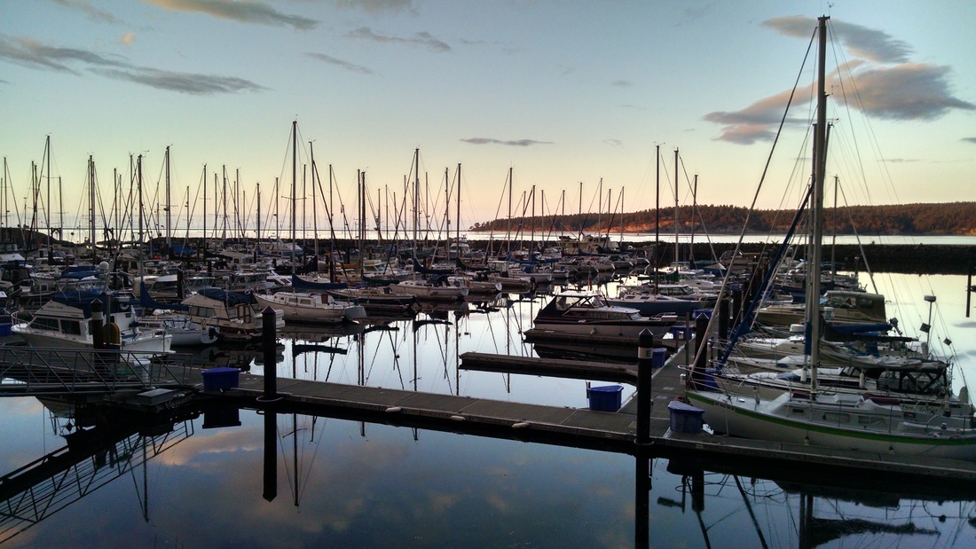
 John Wayne Marina at Pitship PointJOHN WAYNE MARINA AND PARK
You can launch at the launch ramp inside John Wayne Marina for a fee or you can launch from the adjacent park for free. At the park you must walk down a moderately steep ramp to get to the water and there will be some rocks to navigate. It's quite shallow and at low tide you will have a long walk to the water. But it is a perfect spot for beginners because it is well protected from wind, current and boat traffic. Good water shoes or at least flip-flops are highly recommended because the beach and launch area has a number of barnacle covered rocks and the area is littered with broken shellfish shells. There is plenty of parking and bathrooms available. We recommend parking your car or RV for the weekend and camping at John Wayne’s Waterfront Resort and dinner at Dockside Grill which are both a short walk away.
Port of Port Angeles websiteSequim Bay State ParkSEQUIM BAY STATE PARK
The dock fee only applies to watercraft needing to use the boat ramp to launch so SUPs and kayakers can park and launch for free. You do need a Discover Pass to park your car which can be bought on-site. The park is right on the Discovery Trail and offers camping and bathroom facilities.
*Update February 1st, 2018: The boat launch area has received funds for major repairs to replace the failing bulkhead and improve the parking and access to the water. For details visit the Washington State Recreation and Conservation Office project page.
Sequim Bay State Park websitePort WilliamsPORT WILLIAMS
One mile to the north, outside of the bay is Port Williams. Marlyn Nelson County Park at Port Williams provides bathrooms, benches and a boat ramp. You can paddle south through the entrance of the bay, past Washington Harbor and inside to enjoy the rest of the bay but watch the tides carefully because the current can be very strong (see Tides and Currents). You can also enjoy exploring the north side of Travis Spit with spectacular views of Protection Island and Mount Baker. See below for more history of Port Williams.
Clallam County's Port Williams webpageNOTE: Travis Spit is owned by Battelle and private land owners. No trespassing signs are posted the entire length of the spit. The rest of the bay’s shoreline is also owned by private land owners so landing locations are very limited. Also, keep in mind that many tidelands and shorelines are still used for commercial shellfish operations and should not be used as informal bathrooms for paddlers. So plan ahead and if you need to tinkle, Sequim Bay State Park and John Wayne Marina both have well kept facilities available. :)
WEATHER / WEB CAMS
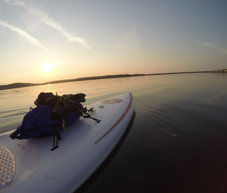
Summer evening on Sequim BayOVERVIEW
Due to the Olympic Mountain rainshadow effect, Sequim only sees an average of 16 inches of rain per year (compared to 36 inches in Seattle) and sees a significantly higher number of sunny days than the rest of Western Washington, earning the nickname "Sunny Sequim." An article in the Seattle Times Magazine, January 22, 1961 said, "...it is the one spot on the Olympic Peninsula where one can stand under a clear sky and watch the rain falling all around a few miles away. Nobody complains about the weather in Sequim; it's a place where the residents can enjoy Puget Sound living without rain hoods."For the most comprehensive explanation of Sequim's unique weather see olympicrainshadow.com.FORECASTS
Weather Underground - Note: make sure you are looking at the Mariner's Outlook station.Windy.com - The best wind prediction around. If you study the maps through the year you'll start to really understand the wind and weather patterns here.NOAA - Note: Wind predictions here often seem off but you'll get notice of Gale and Small Craft warnings out on the Strait which can be helpful.PNNL webcam and weather stationCURRENT OBSERVATIONS AND WEBCAMS
PNNL / Battelle dock - Current conditions and webcam right at the entrance to the bay. (currently not active)John Wayne Marina - Current conditions and 2 webcams (scroll down page for webcams).NOAA Current Conditions - The temperature usually seems about right but it sometimes reports winds that are lighter than what is actually occurring on the water.Olympicrainshadow.com weather station - Located 4 miles north of the bay.New Dungeness Lighthouse - Current conditions and 2 webcams (scroll down page for webcams). Located 8 miles north of the bay.
PADDLER’S TIP: Although it is often sunny at Sequim Bay, there is almost always a light wind during summer days and the temperature generally averages a few degrees cooler than Seattle in the summer (70 degree average in July and August.) The wind is generally from the north and is blowing in cooler air off of the strait. If it's blowing from the south there is probably a storm brewing somewhere nearby. The good news is that the wind is fairly consistent in the summer. It usually starts around 9:30 am and subsides around 7 pm. With glassy water and the unique quality of the light, I think mornings and evenings are without a doubt the best time to paddle on Sequim Bay during the summer. Other seasons can be less predictable and there are so many micro-climates in Western Washington you can't really predict the weather here with much accuracy. The best thing to do is plan for wind and rain on every trip and keep an eye on a number of different forecasts and web cams before you head out.
Tides, Currents and Boat traffic
TIDE AND CURRENTS
To the untrained eye Sequim Bay resembles a calm lake but anyone who has paddled through the entrance to the bay or in front of the marina while the tide is rising knows the currents are complex and potentially dangerous. A quick peak at Bing aerial maps will give you an idea of the places you may see water moving while out on the bay.Flow in and out of the bay at the entrance (Washington Harbor) can be as much as 3.2 to 3.5 meters per second. The best time to paddle through is at slack tide (as it switches from incoming to outgoing tide or visa versa). Experienced and strong paddlers can use eddys and well-planned routes to get in and out if paddling against a flooding (incoming) or ebbing (outgoing) tide. On an ebb tide, the water can also be rough if there is a north wind as the wind waves and swell from the Strait of Juan de Fuca criss-cross the outgoing current. The south end of the bay is far more tame and you will avoid almost all current if you are south of the State Park.Pacific Northwest National Laboratory (located at the entrance to the bay) has created a fantastic video
that will show you the direction and intensity of the current in the bay over a 24 hour period. Science is pretty cool.BOAT TRAFFIC
John Wayne Marina is one of the area’s most popular places for boaters and commercial fisherman to launch. Many are headed north, out to the Strait of Juan Fuca and often at a high rate of speed. Travis Spit creates a bit of a blind corner so you may suddenly find a boat bearing down on you as you cross from one side to another. Luckily there are navigation buoys that create a nice “highway” for them to travel and for paddlers to avoid. To stay out of their way, don’t dilly dally at the entrance to the marina or the entrance to the bay. If on the western side of the “highway,” stay west of the red buoy then stay very close to shore as you approach the Battelle site. The other option is to stay east of the green buoys toward the center of the bay.PADDLER’S TIP: What do the buoy colors mean for those boaters? The easiest thing to remember is RED, RIGHT, RETURN. If the buoy is RED, it should be on the boat’s RIGHT, if it’s making its RETURN trip back to the marina.
SEQUIM BAY PADDLER'S GUIDE MAP
We've created a custom Google map to show you:
* All the points of interest listed below
* Distance measurements between locations
* Locations of buoys and regular boat trafficOnce you've opened the map, use the checkboxes on the left to display more or less data.
History and Points of Interest
1841 Map - davidrumsey.comOVERVIEW
Any discussion of the history of Sequim Bay starts with the S’Klallam people (sometimes spelled Klallam or Clallam). Tribal ancestors have made Sequim Bay and the surrounding area their home for centuries and the current Jamestown S’Klallam Tribal headquarters and administrative buildings are appropriately located at the head of the bay in Blyn.Spanish and English explorers began to arrive and map the area in the early 1790s with Capt. George Vancouver’s expedition being the most notable. But both Vancouver in 1792 and Spanish explorer Manuel Quimper in 1790 failed to spot Sequim Bay behind the long sand spit that separates it from the Strait of Juan de Fuca. Spanish ships commanded by Francisco de Eliza were the first to name the bay "Ensenado de Bertodano" in 1791. In 1841, the United States Exploring Expedition under the command of Lt. Charles Wilkes was the first to map the bay and name the various sandy points located around the harbor. The Wilkes Expedition’s name for the bay was Budd’s Harbour and only Pitship Point and Kiapot Point retain the name given to it by this US expedition.It's believed that the name "Sequim" originated as early as 1853 with coast surveyor George Davidson calling it Squim. The possible source being the S’Klallam village at the entrance of the bay called Suxtcikwi'in. An early translation of ‘Sequim’ was “quiet waters” but more recent study suggests the translation “place for going to shoot,” relating to the plentiful hunting opportunities of waterfowl and elk in the area. The area is rich with naming controversies and Sequim Bay is no exception so you will see some older maps calling the entire bay Washington Harbor when most locals knew that as only the area near the entrance. Download the naming decision card here (pdf download from geonames.usgs.gov).With the arrival of the earliest white settlers and continuing on to present day, the bay and surrounding communities have been home to industries such as logging, agriculture, shellfishing and scientific research while providing endless outdoor recreational opportunities for locals and tourists alike.----------------------------------------------------------------------------------------------------------------------------------------------------------------------------------------------
WANT TO READ MORE?
Fish Tales of Sequim Bay by Harriet Fish (1985)
This pamphlet is a nice little resource for the overall history of the bay.
Available for purchase at the Sequim Museum and Arts Center.Klallam Folk Tales and Klallam Ethnography by Erna Gunther (1927)
Essential reading for S'Klallam history. Most other history books on the Tribe cite Gunther as a source.
Read now on Google Books
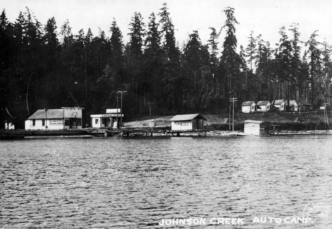
----------------------------------------------------------------------------------------------------------------------------------------------------------Pitship Point - 1977 (D.O.E.)PITSHIP POINT / JOHNSON CREEK / JOHN WAYNE MARINA / JOHN WAYNE'S WATERFRONT RESORT
In the late 1800’s, Pitship Point, also known as Cannery Point at that time, saw a trading post, post office, log dump and cannery all come and go, mostly relocated to Blyn by early pioneer Benjamin F. Dean. But artifacts found in the area show that the original residents, the S’Klallams, were making use of Pitship Point for at least 2000 years before any of the early white settlers.Today, Pitship Point and the adjacent Johnson Creek are home to John Wayne Marina and John Wayne’s Waterfront Resort. Actor John Wayne visited the area on his boat the Wild Goose and fell in love with the area. In 1968, he purchased a large tract of land and donated a portion so that a marina could be built. Constructed in 1985, the marina is operated by the Port of Port Angeles and features Dockside Grill restaurant, boat ramps and moorage, a public park as well as bathroom and laundry facilities.- Click the picture at right to go to the Department of Ecology Coastal Atlas Shoreline Photo site and see what Pitship Point looked like before John Wayne Marina was built.
Johnson Creek Auto CampJohn Wayne’s Waterfront Resort is still owned by the Wayne family and provides historic cabins, camping and RV sites with amazing views of Sequim Bay. With cabins built in 1910, the resort has some of the oldest structures on the bay and the site has long been used as a respite for travelers, previously as Silver Sands Resort, Hague's Resort and Trailer Park